GTA could see up to 30 cm of snow as system tracks up U.S. East Coast
A major winter system tracking from the U.S. Deep South may bring up to 30 cm of snow to parts of the GTA Sunday, with a polar vortex pushing temperatures well below freezing.
Copy link
By Torontoer Staff
Parts of the Greater Toronto Area could pick up as much as 30 centimetres of snow Sunday as a large winter system tracking up the U.S. East Coast edges into southern Ontario. The arrival of the storm will coincide with an Arctic airmass linked to a polar vortex, which may push temperatures deep below zero.
Forecasters say the storm will form over the southern United States and move northward over the weekend. The exact track remains uncertain, but several models now show the northern portion of the system reaching southern Ontario late Saturday into Sunday, bringing a period of heavy snow and strong winds.
Storm track and timeline
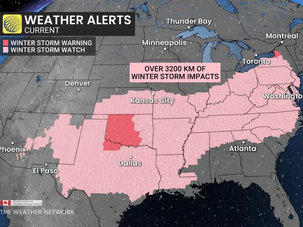
The Washington Post reports the system will affect a roughly 3,200-kilometre corridor from the Southern Plains and Southwest to the East Coast, beginning Friday. The storm is expected to peak on Sunday, with significant impacts across parts of the U.S. and the potential to clip southern Ontario.
The storm is expected to peak on Sunday, with about 55% of U.S. residents experiencing snow, sleet or freezing rain simultaneously.
Washington Post
The Weather Network is advising that southern Ontario could see localized snowfall totals up to 30 centimetres depending on the track and intensity of the northern portion of the system. Timing and amounts will vary across neighbourhoods, with the heaviest snow most likely Sunday.
Cold air and wind: the added hazard
In addition to snowfall, an Arctic airmass tied to a polar vortex will keep temperatures dangerously low through the weekend. Some forecasts suggest temperatures, or wind chill values in exposed areas, could fall toward -40 C, increasing risk for frostbite and hypothermia during prolonged exposure.
Cold temperatures will also make road conditions more hazardous. Snow that binds to cold pavement can reduce traction, and wind gusts will create blowing snow and reduced visibility in open areas and on highways.
How the storm forms
Meteorologists say the storm will develop where Pacific and Gulf moisture and milder air meet a deep pool of cold continental air. That mixing, combined with energy in the atmosphere, will allow a large low-pressure system to organize across the southern U.S. before lifting northeast along the coast.
Because the system is still organizing, details remain subject to change. Small shifts in the track could mean large differences in local snowfall totals and the mix of precipitation across southern Ontario.
Practical steps for the weekend
- Check forecasts from Environment and Climate Change Canada and The Weather Network before travel.
- Allow extra time for commuting and consider postponing non-essential trips during peak snowfall.
- Prepare an emergency kit for your vehicle with warm clothing, a blanket, food, water, a flashlight and a fully charged phone.
- Protect pipes by insulating exposed plumbing and letting faucets drip slightly if temperatures fall very low.
- Look after vulnerable neighbours and confirm heating systems are working.
Municipal services and transit agencies may alter schedules or priorities depending on accumulation and wind. Residents should monitor updates from local authorities on weather advisories, road conditions and transit changes.
What to watch for next
Expect forecast updates through Friday and Saturday as models refine the storm track. If the system trends farther south, southern Ontario will see less impact. If the northern lobe strengthens and tracks closer to the Great Lakes, snowfall totals and winds will increase across the GTA.
Follow official forecasts and local advisories for the most current information and safety guidance.
weathersnowGTAwinterstorm